Rocks, Roots and Rocky Mountains
A Geologist’s Journal: 33 Days of Enlightenment on the Colorado Trail

Rocks, Roots and Rocky Mountains
This is my 2nd in a series of books written about long distance backpacking adventure from the perspective of a geologist
Chapter Excerpts:
-

Introduction: A Brief Geological History of the Colorado Trail
…this unusual juxtaposition between the upper and lower plates provided the required conditions for high angle, basement involved block faulting of the Laramide Orogeny. Preceding this orogeny was the Sevier Orogeny which formed a fold and thrust belt west of the Laramide deformation belt.
But we are getting ahead of ourselves. Long before these two important orogenies, Colorado and the rest of Laurentia—as the early forming continent was known—was slowly being stitched together by accretions of one new terrane after another. With an understanding of the simple concepts of plate tectonics, let’s start at the beginning.
Early Crustal formation under Colorado in Precambrian time
The geologic story of the Colorado Trail begins roughly 1.76 billion years ago when a series of volcanic arcs collided with the two-billion-year-old Archean age crust under present day Wyoming (figure 5). Over the next 40 million years these collisions collectively became part of the accreted terrane known as Yavapai Province, a NE-SW trending slab of crust added to the growing proto-North American continent. Subsequent accretions (such as the Mazatzal and Granite Rhyolite provinces) were added to the southeastern margin (present day coordinates) as one collisional orogeny after another added new crust to the growing continent over the next 300 million years. Erosion of emergent highlands beginning around 1700 million years ago (or Ma, meaning mega-annum) yielded widespread deposition of silts and sands that later were metamorphosed into thick beds of quartzite, which are present in bedrock in south central Colorado. Periodic pulses of magma pushing up through fractures in the juvenile crust at 1700 Ma, 1400Ma and 1100 Ma formed large plutons eventually solidifying into massive granitic emplacements such as the Pikes Peak (1100 Ma) and St. Kevins batholiths (1400 Ma).
For the next billion years following the Yavapi orogeny, Colorado was a near-lifeless, bleak place as periodic seismic events spewed magma onto the surface of this rocky desolate landscape. By about 900 Ma, all the continental fragments on planet Earth had assembled to form the supercontinent Rodinia…
-

Foreword
I have often heard the Appalachian Trail referred to as the “green tunnel,” where hikers spend hours or perhaps an entire day hiking through the dense canopy longing for a glimpse of the scenery surrounding them. In places like the North Carolina balds or the New England alpine zones these mountains provide panoramic views of the surrounding terrain. Most of the views, however, are hidden by impenetrable tree cover, thus creating a continuous yearning for that anticipated peek into distant horizons. Colorado by contrast, has very different kinds of mountains. They are younger, more rugged and grandiose—and elevated to a much higher level by tectonic forces whose origins can still spark debate between geologists.
The Rocky Mountains.
Just hearing those three words invokes a mental image that is majestic, mysterious and inviting. They appeal to the senses, creating a feeling of awe, inspiring the soul to go there and experience the challenges of those steep sculpted blocks of granite, gneiss and red arkosic sandstone. This multitude of rock types begs for an explanation—or at least a brief discussion. Much of the bedrock here is naked and unadorned, laid bare by the altitude and climate…
…I have visited the Rocky Mountains in the winter months many times to ski, always intrigued by what lay beneath the heavy snow cover. But what I have never done until now was to immerse myself into the depths of these incredible ranges, following a continuous footpath up and over pass after pass to experience the vast openness of this part of North America.
My journey would start just south of Denver at the front range and for the next month, I would enter a world of discovery and enlightenment before reaching my endpoint near Durango. Although I was prepared for the journey, I wasn’t aware of what unexpected adventures lay ahead of me.
This book is the story of my 33-day trek on the Colorado Trail through these wonderful mountains. Written from the perspective of a geologist, the book will occasionally take the reader on a short side trail to explain a bit about the rocks below the footpath. However mostly this book is about the splendor and adventure I experienced on this amazing month-long excursion…
-

Chapter Four: Ski Slopes and Bike Races
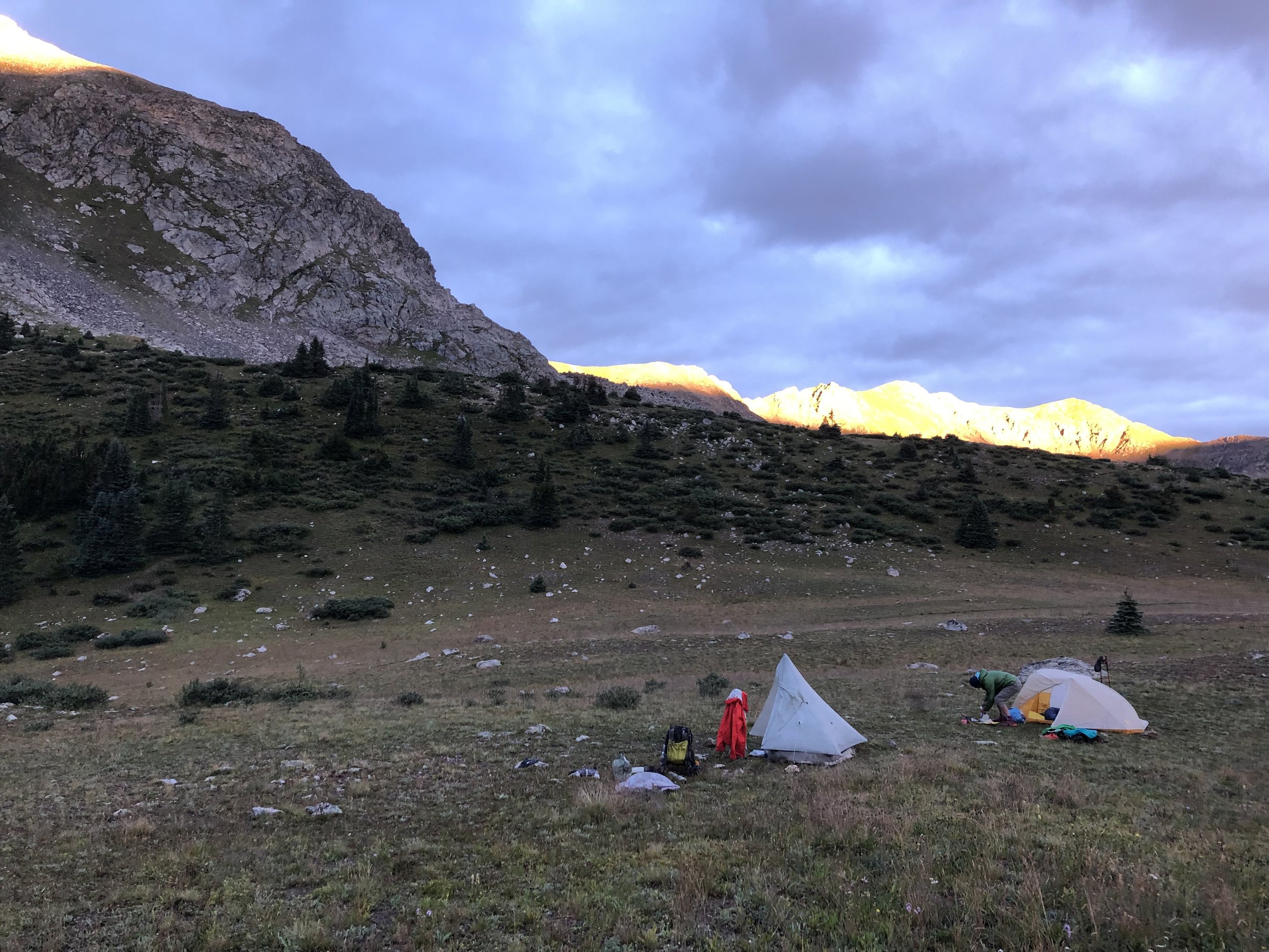
Day 9: Tuesday, August 16, 2022
Gold Hill Trailhead to Guller Creek Campsite
…I was very concerned about the weather. My trusty iPhone app called for lightning by 11 AM. I didn’t know if we would be able to get up and over Tenmile Ridge by then. The top of the ridge was over 8 miles away and at my normal 2 mph pace I estimated 4 1/2 hours with a few breaks. And then two more miles down the other side before hitting the tree line. This meant we were going to be above tree line until 11:30 assuming we took no breaks.
Last February while skiing at Copper Mountain, I could see all these peaks and the top of the pass that we would soon cross over. I was excited to know that I was going to be walking on that very ridge line that I stared at dozens of times.
For the first couple of miles the path led us over some low foothills where most of the rocks appeared sedimentary. These were Jurassic to early Cretaceous age rocks of Dakota and Morrison formations. Later after crossing several major faults, the rocks under our feet suddenly became a billion-and-a-half years older. Those gneisses and schists were part of the original crust stitched together when the Yavapai Terrane collided with proto-Laurentia, forming the first continental crust under Colorado about 1.7 billion years ago, and then much later uplifted during the Laramide orogeny 80 million years ago.
At one point we encountered a cow moose eating grass on the trail. Thankfully no baby could be seen nearby. Like bears, cow moose are extremely protective of their young and present a danger to any hiker who may unknowingly get too close. We stopped and watched her for a while as she nonchalantly grazed on her breakfast of tall grass. Fully aware of our presence, she eventually lost interest in us and began slowly plodding across the field toward some cover.
After crossing Miners Creek, the trail merged with the historic Miners Creek Trail. On the way up there were some very steep parts of the trail and Dave pulled a muscle in his leg trying to…
-

Chapter Seven: Trekking at the Top of the World
Day 16: Tuesday, August 23, 2022
Pond before Cottonwood Pass to Tincup Pass Road campsite
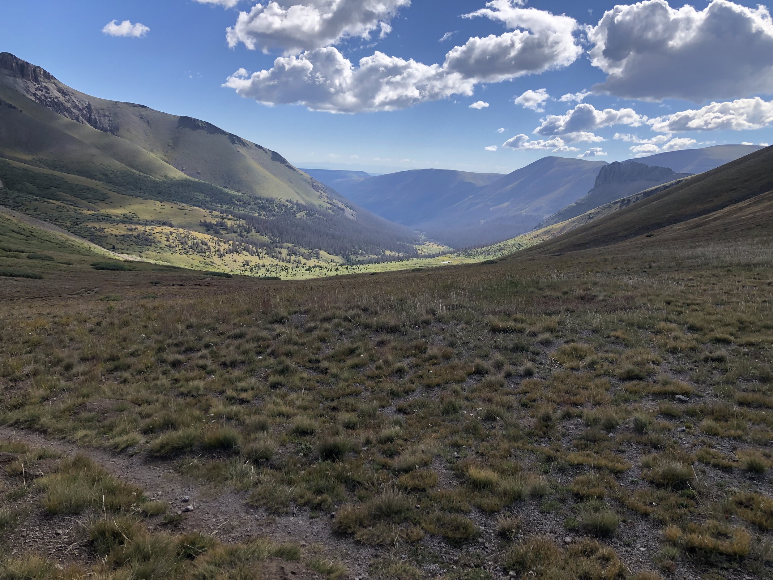
…on my way up to the pass near Tin Cup, I could see a potential storm brewing but I continued up the exposed mountain. The sky was thick with clouds, seeming almost within reach at these altitudes. Earlier I took a snack break where I had briefly considered stopping for the night near a stream in a semi-protected flat campsite surrounded by sagebrush. Behind me was a classic tongue of a slowly moving rock glacier coming off the steep sided east flank of Mt. Kreutzer. Scanning the horizon, I could see sheets of rain slowly approaching as each successive distant peak disappeared into oblivion. I recall looking at the trail ahead as it zig-zagged toward the ridgeline at nearly 13,000 feet and wondering what my odds were for safe passage. The skies darkened as the wind was picking up speed and I felt a surge of adrenalin. I decided to take my chances and make a run for it, despite the consequences.
After a frantic half mile scramble up the steep face, a dark curtain of heavy cold rain suddenly caught up with me, followed by an onslaught of hail. In the shroud of this icy deluge, I didn’t notice the lightning but I could hear the loud cracking of nearby thunder echoing against the barren mountainsides. I knew it was time to seek cover but looking around I saw nothing but the rocky path ahead of me. Suddenly, I spotted a large rock jutting out near the path. I hastily removed my pack, set my poles aside and with my rain jacket covering me, hunkered down in an upright fetal position next to a large outcrop of gneiss. I remained there for about twenty minutes until the thunder stopped. While still being pelted with hail, I emerged from my faux shelter and continued up the steep switchbacks toward the pass.
Crossing into the next valley the fierce rain and hail slowly diminished. I could now see the trail ahead as it passed through an enormous talus slope, likely another rock glacier. I wondered who had carved this trail through these massive erratic boulders. Was this an old road or path from the early mining days? The filling in of the gaps between each massive boulder to make a passable route must have been an enormous task. I wondered what superhumans were responsible for doing this…
-
Chapter Nine: Mushrooms, Volcanoes and Dead Cows
Day 23: Tuesday, August 30, 2022
Bluff campsite overlooking Cochetopa Creek Valley to stealth site on Snow Mesa
…my destination for the day was Snow Mesa, a large, flat alpine plateau made up of andesite lava flows associated with the early phases (35-30 Ma) of the San Juan volcanic event. The ridge tops are primarily ash flow derived tuffs—the remains of the large volume recurrent eruptions of ash (30-26 Ma)—that came later. All the Tertiary age volcanic events were explosive eruptions far more violent than anything occurring in recorded history. Volcanic events occurring near the center of continents are generally very explosive because they contain magma derived from melted continental crust containing higher silica content than magmas produced along continental margins or beneath oceans. The high silica content makes these magmas much more viscous and so they are more explosive. All types of magma are gassy but this increase in viscosity causes higher pressures to develop leading to more explosive eruptions. This results in lots of ash and pumice being ejected between and after lava flows.
There were several more unexpected valleys requiring steep climbs awaiting me before my arrival to this place. I passed a large campsite which would be the last camp below tree line that I would see. I briefly considered stopping for the day but quickly returned to the path and continued ahead. Maps and Moxie were behind me and I presumed that they would stop here for the night. It was already after 4 o’clock with at least 4 more miles to camp and this was the point of no return. As I crossed over each new pass I expected to see a grassy plateau but the trail relentlessly continued over one saddle and down into the next valley again and again.
While coming around one of the last passes toward Miners Creek, I ran into Baby Nora with her mom, dad and uncle. Nora’s face was beet-red from sunburn but she appeared happy and content. They enthusiastically told me about a friendly moose encounter they had near a pond on the large mesa ahead. In less than 15 minutes, I finally arrived at Snow Mesa. I scanned the vast, treeless plateau and began looking for somewhere to camp. I stopped for water at a cold lively stream and later passed by a small glacial pond where I thought I might see the moose…
-

Chapter Eleven: Lava Flows, Gorges and the San Juans
Day 27: Saturday, September 3, 2022
Campsite near Colorado Trail Friends Yurt to stealth campsite just before Cuba Gorge
…I looked down to see a textbook example of a xenolith exposed on the far hillside. These are chunks of some other type of bedrock incorporated into a magma melt. They really should be more common than they are but its always exciting, at least for a geologist, to see one. On the way up to the next mountain pass, Ben and Mark finally caught up to me. We hiked for a while until their pace took them beyond my sight. They are both much younger and can maintain a faster pace as trail gradient increases. I later joined them for a lunch break amongst some randomly scattered andesite boulders after crossing over the pass on the high saddle. The sun was blazing and burning my skin, but a cool, light breeze brought relief. We talked about meeting at a nice camp area near a spring for the night, many miles ahead. From our morning starting point that would mean a 25-mile day. We hiked together after our break but soon the two were ahead of me and once again out of my sight. For the rest of the day I was really dragging.
I took a short rest and watered up near a pond at Cataract Gulch. There were a lot of nice spots to camp but I wasn’t ready to quit for the day just yet. Still unrefreshed, I plodded over the next hill and at about 3 o’clock ended the day at a low flat saddle near a trailhead for Middle Pole Creek Trail. It was a nice stealth campsite—broad and expansive but very windy. The gravelly surface of ancient solidified volcanic rock had been tortured by the action of rain, wind and ice over the millennia. It seemed entirely possible that no human had ever set foot on this place. I felt a strong sense of being alone here. This was such a desolate setting yet beautiful, surrounded by craggy peaks in every direction. And I felt really tired all day. Was it the altitude?
The intensifying wind brought a surprisingly bitter chill to the air as I struggled to erect my tent on the rock-hard ground. After unloading my gear for the night, I enjoyed a satisfying dinner of ramen and tuna. While slurping my noodles, I saw two specks of color moving steadily along a ribbon trail on the far-off forsaken hillside. Soon, I could make out two hikers approaching…