Foreword
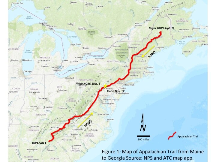
This book is the story about my five-month journey hiking the Appalachian Trail (Figure 1). It is written as a series of daily logs originally transcribed from my daily journals, then embellished with additional details resulting from further recollection and research. All of the stories are true, and many contain elements of human interest relating to the many people I met on my adventure. Perhaps the most enjoyable aspect of doing such a trek is encountering so many interesting people along the way.
My goal in assembling this book was to provide entertainment and information for two main audiences. First, for those who have hiked the trail, I included stories relating to places and things all of us have seen, along with frequent observations about some of those mysterious rocks beneath our feet. For those new to the trail, or who have never hiked long distances, this is a glimpse into the wonders and excitement out there to be discovered, as told by just one of the many thousands of past thru-hikers.
As a geologist, I have added a fair amount of content pertaining to the rocks I encountered, their geologic history and relevance to the present trail. Some of the content I was already familiar with or already knew, some I relearned from review of maps and literature sources, and still some content I was learning about for the first time. I have woven those explanations and observations into stories about my daily experiences. I have also attempted to keep it fairly simple, owing to what I can only hope will be a mixed audience of readers. In addition, most of my background as a geologist has been in studying sedimentary basins, and most of the rocks encountered along the trail were, well, not sedimentary. Metamorphic and igneous rocks such as those found in the Blue Ridge and New England are far more prevalent and provided an enjoyable re-learning experience for me!
During my career, one of my pet research areas was searching for evidence for reactivation of faults in the basement complex below the Appalachian sedimentary basin, which affected depositional patterns and later structural development throughout the Paleozoic era. This was one of my favorite topics in geology and involved the use of many types of geophysical datasets as well as massive amounts of well-log data in order to image, model, and interpret deep crustal faults in the metamorphic and igneous basement complex. I spent thousands of hours researching, studying, and mapping this phenomenon and conducted technical presentations on dozens of occasions. Those deeply buried basement rocks I had spent so much of my career studying and mapping were the same rocks under my feet throughout most of the Blue Ridge physiographic province from Georgia to Pennsylvania.
As I walked each day on nearly every imaginable kind of rock over the almost 2,200 miles, the surrounding geology was always on my mind. It is woven into the fabric of the text. However, this book is in no way an attempt to match or replace any of the existing geology guides to the trail, such as Chew’s 1988 masterpiece, Underfoot. It is rather an attempt to infuse my story with frequent musings pertaining to the rocks I encountered each day, including a lot of interesting and useful advice that a future thru-hiker may appreciate.
In the Appendix section, I have combined an assortment of published trail data with analyses of my own data collected over my 150 days. Using Excel and its regression analytics, I looked for correlations between multiple parameters collected along the way and used graphics to highlight various aspects of my journey. The resulting graphs and charts will hopefully be of interest.
Lastly, I hope readers find my occasional meanders into “rockthink” both entertaining and informative. Seeing and touching the rocks at the surface is akin to just seeing the above-water tip of the iceberg. And, who knows, out of all the future readers of these pages, perhaps just one might be bitten by the geology bug and decide to spend five months on this same journey!

Elevation Profile of the AT
Elevation profile of the Appalachian Trail showing each night’s stay: tent, shelter or hostel/motel.
It is said that a thru hike on the Appalachian Trail is more than 500,000 vertical feet of total ascent/decent. Over the course of a thru hike, this is the equivalent of 16 or more ascents from sea level to the top of Mt. Everest. That’s about one ascent and descent cycle about every 9-10 days!